II. The Example--Europe from Roman to Modern Times
The Belgian historian Henri Pirenne proposed,
some 50 years ago, the novel thesis that the major features of the
western Roman Empire survived the barbarian invasions of the fifth
century and were finally destroyed in the eighth and ninth centuries
as an indirect consequence of the Arab conquest of the Mediterranean.
According to the Pirenne thesis, the Roman civilization of the west
was heavily dependent upon east-west Mediterranean trade, and that
trade ended with the Arab conquest. Later writers have on the whole
accepted Pirenne's view that the barbarian invasions produced no
sharp break with previous institutions, while disagreeing as to the
causes and timing of both the decrease in trade and the eventual
transition to feudal society.[6]
According to these views, the German kingdoms
were centralized monarchies, deriving their revenue (as did the Roman
Empire) largely from taxes on trade. At some later time, variously
estimated from the seventh to the tenth century, this system broke
up, leading eventually to feudalism.
The question of interest to us is not exactly
when or why trade declined but the connection between the economic
and the political change. The effect of the economic change was to
lower drastically the potential tax revenue from tolls on trade. In
addition, an agricultural revolution seems to have occurred in
northern Europe at about the same time.[7]
If as seems likely, population growth was controlled by the supply of
food, both the long-run demand for agricultural products and the
long-run supply of agricultural labor should have been relatively
elastic, and increased productivity would be reflected in higher
rents. According to our theory, a change in the potential tax base
from trade to rent should result in a sharp decrease in the size of
nations. This is exactly what happened. The large, centralized German
kingdoms, supported largely by taxes on trade, were replaced by a
system of very small, independent domains, supporting themselves from
the income of the land.[8]
The size of nations rose with revived trade
during the next few centuries. So far the development was merely a
reversion toward the Roman pattern. Then in 1348 the bubonic plague
reached Europe, and by the end of the century it had reduced the
population by about 40 percent.[9]
The result was a drastic decline in rents and increase in
wages.[10]
If our theory is correct, this should have led to an increase in both
the size of nations and the degree to which language groups were
contained within nations. As we will see when we discuss our
calculations, that is precisely what happened.
In the course of the eighteenth and nineteenth
centuries, a series of developments--a second agricultural
revolution,[11]
the opening up of the new world to extensive immigration, and the
Industrial Revolution--caused a dramatic rise in incomes, beginning
somewhere between the middle of the eighteenth and the middle of the
nineteenth centuries.[12]
Income from labor became an important taxable resource. During this
same period, nation size again rose substantially, and the polyglot
state of Europe developed into the modern "national" state, precisely
as our analysis of the effect of taxing labor suggests that it
should. In the words of Henry Kissinger, "It would have occurred to
no one in the eighteenth century that the legitimacy of a state
depended on linguistic unity. It was inconceivable to the makers of
the Versailles settlement that there might be any other basis for
legitimate rule" (1973, p. 145).
III. Some Preliminary Tests of the Theory
To test our theory, we must identify
t-nations; that might best be done by carefully examining the
political and diplomatic history of every nation in the area we are
considering, in order to determine which were single t-nations, which
were made up of several t-nations, and which were component parts of
larger t-nations. Such a study would be beyond the scope of this
paper. Instead, I used the following rules:
1. Anything identified as a state in the standard historical atlases[13] was assumed to be a t-nation except for the Holy Roman Empire after 911 and France from 987 until 1400. In these two cases, the component states or major feudatories were considered t-nations for taxes on trade.[14] Zollvereinen were also considered t-nations for taxes on trade.
2. Where more than one state was under a single ruler, the group of states was considered a single t-nation (this includes states under the church).
A second problem is the paucity of economic
and demographic data for the periods we wish to study. This was dealt
with by a variety of simplifying assumptions which will be described.
Given the difficulties of testing our theory
and the limited scope of this paper, I prefer to regard this section
as a preliminary set of tests, designed more to show how the theory
might be tested than to confirm or refute it conclusively.
Taxes on Trade
If our arguments are correct, t-nations should
tend to shape themselves so as to maximize the total revenues
received from taxes on trade, and that tendency should be greater as
the amount of trade available to be taxed is greater. We do not
expect to observe a perfectly efficient outcome, partly because our
information with respect to both trade routes and political
boundaries (of t-nations) is imperfect but also, more importantly,
because shaping nations to maximize tax revenue from trade is costly.
We do expect that the larger the amount of trade, the higher the cost
a nation is willing to bear in order to tax it more efficiently and
so, ceteris paribus, the higher the tax-efficiency index (TEI).
Whether the relevant variable is the absolute value of trade or its
value relative to other sources of revenue is somewhat unclear in our
model. To the extent that the costs of shaping a t-nation to tax
trade efficiently are independent of its total revenue and of that of
other t-nations, it is the absolute value of trade which is relevant;
to the extent that the costs are proportional to total revenues
(either because they involve administrative costs which increase with
increasing volume of government or because they involve the costs of
conflicts with neighboring states), it is the relative value of trade
in relation to the value of other revenue sources.
To construct an index of tax efficiency, I
assumed that trade declines linearly with total taxes on the trade
route. Let the total volume of trade along a single trade route be
V, the number of nations taxing the route be n, the tax
rate of the ith nation be TI , and the total
tax rate along the route T. We have
By definition, t-nations maximize
independently. So nation i sets TI to
maximize its revenue, RI:
So we see that, where n nations control a
single trade route, the total revenue collected will be proportional
to n/(n + i)2. When two nations each control one of two
parallel trade routes between the same two points, the assumption of
independence implies that they will collect no taxes at all; as in
the familiar case of perfect competition, all profits are competed
away. We compute our TEI, for a given political map and a given set
of trade routes (see figs. 1 and 2), by calculating the total tax
collected under these assumptions and dividing it by the total tax
that would have been collected had each trade route been controlled
by a single t-nation.
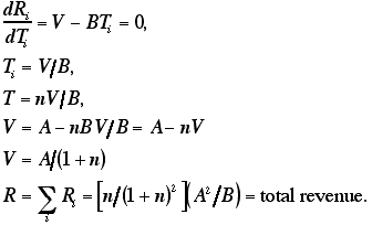
Consider, for example, the trade route labeled
i on figure 1A, which follows the Adige River from Trent to the
Adriatic. It goes through the territory of two nations, as shown by
its diagram on figure 2A. So n is 2, the total tax revenue that would
be collected is (2/9)(A2/B), the total tax collected by a
single revenue-maximizing state controlling the same route would be
(1/4) (A2/B), so the TEI for that particular route is 8/9.
Now consider route ii on figure 1A, running
along the Po from Pavia to the Adriatic. Here, as in all our
calculations, we assume that a nation must control both banks of a
river at one point in order to control commerce passing along the
river at that point. Since for most of the route the two banks of the
river are controlled by different nations, one has in effect two
parallel routes, one controlled by Lombardy-Venetia and one by
Sardinia and then by Parma. The routes join into one where the river
flows through Lombard-Venetian territory, then separate again where
it becomes the border between Lombardy-Venetia and the Papal States.
Finally it flows again through Lombard-Venetian territory to the
Adriatic. The situation is diagrammed in figure 2A. Since parallel
routes under our assumptions produce no revenue, we may remove the
parallel segments, yielding diagram ii' of figure 2A. We see that, in
spite of the complication of the original diagram, only one nation
(Lombardy- Venetia) is in a position to tax the trade route. No boat
without permission from the Lombard-Venetian authorities may travel
from Pavia to the sea; any boat having such permission may, without
permission from any other nation, simply by keeping to the left bank
of the Po. So n is 1, and the TEI for this route is unity. The TEIs
calculated from figures 2A and 2B are shown in table 1.
S: Kingdom of Sardinia; LV: Lombardy-Venetia;
Ty: Tyrol; Pr: Parma; P: Papal States; T: Tuscany.
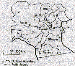
Fig. 1B.--Northern Italy in 1378. Vi:
domains of the Visconti; M: Marquisate of Montferrat; C: Gonzaga; Tr:
Bishopric of Trent; D : Della Scala dominions; C: Carrara; V:
Venetian Republic; P: Papal States; T: Tuscany. (Tr and P are parts
of the same t-nation.)
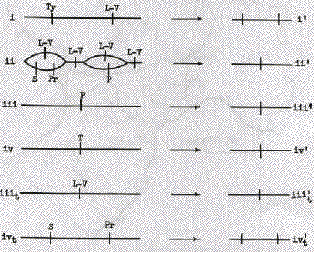
Fig. 2A.--Schematic diagrams of trade routes,
northern Italy, 1854
To construct our trade routes, we utilized the fact that water transport was until the nineteenth century very much cheaper than land transport.[15] Our first set of trade routes was constructed by finding, on an economic map of Europe in 1500 (Putzger 1965, pp. 70-71), all cities of over 20,000 people and connecting them to the sea by any available navigable rivers.[16] Routes iii and iv on figures 1A and 1B are examples. All routes were assumed to have the same amount of trade, save that those from cities of over 50,000 were treated as having twice the trade of the others. The TEI was calculated for each city's trade routes and the results averaged, with the large cities being counted twice. The efficiency indices calculated from these trade routes are shown in the first row of table 2.
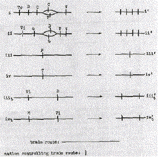
Fig. 2B--Schematic diagrams of trade
routes, northern Italy, 1378
It may be objected that, by using a single set
of trade routes for all times, we ignore the possibility that
economic change may have altered the pattern of trade. But if we
recalculate the trade routes at each period, we run the risk that a
high or rising TEI may reflect trade routes adapting themselves to
the shape of nations rather than the other way around. By calculating
trade routes on the basis of early data, we at least guarantee that,
if the TEI rises after the medieval period, as we expect, it will do
so in spite of, not because of, the imperfections of our
method.
The larger nations are, the fewer of them a
trade route will on average go through. So a high TEI might be merely
a side effect of some other factor that made nations large. To
eliminate such effects and determine to what extent t-nations
actually shaped themselves to trade routes, I constructed a second
set of "trade routes" very similar to the first, save that there was
no reason to expect any trade on them. They were constructed by
translating each real trade route by 100 kilometers in each of two
orthogonal directions.[17]
Routes iiit and ivt on figures 1A
and 1B are the routes corresponding to iii and iv.
These imaginary trade routes provided the control; I calculated the
tax-efficiency index for them just as for the real trade routes. I
then divided the real TEI by the control TEI, to give a measure of
the degree to which nations shaped themselves to trade routes. The
results are shown in line 2 of table 2.
|
TABLE 1 |
||||||
|---|---|---|---|---|---|---|
|
|
||||||
|
|
|
|
||||
|
Route |
|
|
|
|
|
|
|
i |
|
|
|
|
|
|
|
ii |
|
|
|
|
|
|
|
iii |
|
|
|
|
|
|
|
iv |
|
|
|
|
|
|
|
iiit |
|
|
|
|
|
|
|
ivt |
|
|
|
|
|
|
|
|
|
|
|
|
|
|
|
|
|
|
|
|
|
|
* Corresponds to line 2, table 2.
+Corresponds to line 4, table 2.
One defect in this procedure is that our real
trade routes are rivers, and our controls are not. Rivers may affect
the shape of nations in ways unrelated to our theory (in particular
by providing easily defended boundaries), and such effects may
distort the results shown on line 2 of table 2.
To avoid this problem, I constructed another
set of trade routes and controls. I used the economic map to estimate
the relative amount of trade on different rivers. I then selected a
group of the highest-trade rivers and paired each with a nearby
low-trade river of comparable length; the first set I used as my
trade routes, the second as my controls.[18]
Route ii on figures 1A and 1B is a
high-trade river and route i the corresponding low-trade
river. The results are shown on lines 3 and 4 of table 2.
|
|
TABLE 2 |
|||||||||||||
|---|---|---|---|---|---|---|---|---|---|---|---|---|---|---|
|
|
|
|||||||||||||
|
|
|
|
|
|
|
|
|
|
|
|
|
|
|
|
|
1.
Cities |
|
|
|
|
|
|
|
|
|
|
|
|
|
|
|
2.
Cities/cities displaced |
|
|
|
|
|
|
|
|
|
|
|
|
|
|
|
3.
High-trade rivers
|
|
|
|
|
|
|
|
|
|
|
|
|
|
|
|
4. High
trade/low trade |
|
|
|
|
|
|
|
|
|
|
|
|
|
|
The results of these calculations are somewhat
mixed. The absolute TEIs behave about as we would expect, reaching
their lowest value from about 1,000 to 1,400 and then rising. The
relative TEIs are less satisfactory. The values shown in line 2 of
table 2 seem to fluctuate almost randomly; those shown in line 4
rise, as one would expect, with increasing trade in the sixteenth,
seventeenth, and eighteenth centuries but show no previous dip. Both
lines show dips in the second half of the nineteenth century and in
the twentieth. One explanation is that, as nations became large, the
tax efficiency became high even for a random set of trade routes; a
one-nation world, after all, is perfectly tax efficient for any set
of routes. Another explanation is that our trade routes were
calculated from an economic map for 1500, using an assumption (water
transport) designed for a premodern world. The later the date, the
less likely it is that our "trade routes" actually carry more trade
than our "controls." A third explanation is that the dip reflects the
declining relative importance of taxes on trade.
The Effect of Taxes on Labor
According to our arguments, nations should
tend to shape themselves so as to include entire linguistic groups
within their borders, and the degree to which they do so should be
greater as the amount of their revenue derived from taxes on labor is
greater. The argument does not necessarily imply that nations will
tend toward linguistic homogeneity; a nation containing all of two
language groups is not more subject to tax competition than a nation
containing all of one (although it may be unnecessarily bearing other
diseconomies related to its size). It does imply that linguistic
regions will tend to become nationally homogeneous, that one
linguistic region will tend to consist only of territory belonging to
a single t-nation. To test this conjecture, we calculate the
linguistic homogeneity index (LHI), defined as the average over all
persons of the percentage of speakers of each person's language who
live in the same t-nation as he does. Formally
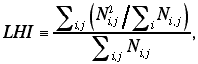
Where Nij is the number of people
in nation i speaking language j. This index, unlike TEI, is not
derived from any actual calculation of taxes that will be collected,
since we do not have a satisfactory simple model of this kind of tax
competition.[19]
We expect, however, that the larger the percentage of a citizen's
language group living outside his nation, the easier it is for him to
migrate and the lower, in consequence, the taxes that can be
collected from him.
In order to evaluate the index, one requires a
census of the number of speakers of each language in each i-nation.
For many of the times at which we wish to evaluate it, no such data
exist. I have therefore made several simplifying assumptions. The
first is that the linguistic map of nineteenth-century Europe
accurately represents linguistic boundaries from the twelfth century
to the present. This assumption appears plausible, to judge by the
near identity among linguistic maps of central Europe in 1500 and
Europe in the nineteenth and twentieth centuries.[20]
The second assumption is that the relative populations of linguistic
regions have stayed the same over the same period.[21]
The third is that the population of each linguistic region at every
time is uniformly distributed over the region. It would be possible,
but laborious, to improve on these assumptions by the use of such
historical data on population as are available.
Of the unrealistic elements in our
assumptions, only one seems likely to effect qualitative results. Our
linguistic map differentiates only crudely among
dialects.[22]
At the earliest times we are considering, variations among dialects
were many and large; even today the difference between, say, Austrian
and Swiss German (both of which are here classified as High German)
is substantial. I may have underestimated the LHI for the earliest
periods by ignoring differences between dialects that were at that
time virtually separate languages. Using these assumptions, I
calculated values for LHI. They are shown on line 1 of table 3 and in
figure 3.
Here, as with taxes on trade, we would like to
separate out the effects of changes in the size of nations from
changes in their shapes. To do this, we select matched groups of
countries at adjacent dates, by the following procedure.
First, for each pair of adjacent dates (1250
and 1360, e.g.), we calculate the combined population (measured as a
fraction of the combined population of all nations)[23]
of the 15 largest nations (by population).
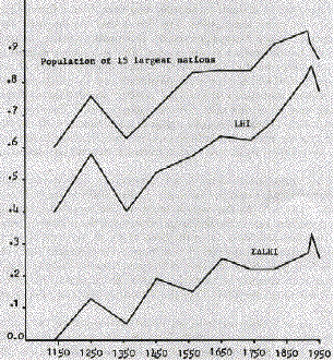
Fig. 3
This is shown on line 2 of table 3 and graphed as line 2 of figure 3. Since the figure for 1250 is larger than for 1360, we proceed to choose a group of 15 nations in 1250 whose combined population is the same as that of the 15 largest nations in 1360. Our choice rule is to order the nations by size, remove a consecutive sequence of n nations, calculate the combined population of the 15 largest nations remaining, and compare it with the population we are trying to match. We start with n = 0 and continue until we have a match to within 2 percent; if the same value of n generates two different groups that match to within 2 percent, we take the closer match.
Having chosen our groups of 15 nations (the 15
largest in 1360 and a matching group of 15 in 1250), we calculate the
LHI for each group. Their difference is shown as ![]() LHI
on line 3 of table 3. It is a measure of the change in LHI from one
date to the next caused by changes in the shapes of nations,
independent of changes in their sizes. The sum of
LHI
on line 3 of table 3. It is a measure of the change in LHI from one
date to the next caused by changes in the shapes of nations,
independent of changes in their sizes. The sum of ![]() LHIs
from 1140 on is shown on line 4 of table 3 and graphed in figure 3;
it represents the cumulative change in linguistic homogeneity
controlling for changes in nation size.
LHIs
from 1140 on is shown on line 4 of table 3 and graphed in figure 3;
it represents the cumulative change in linguistic homogeneity
controlling for changes in nation size.
|
TABLE 3 |
|||||||||||
|---|---|---|---|---|---|---|---|---|---|---|---|
|
|
|||||||||||
|
|
|
|
|
|
|
|
|
|
|
|
|
|
1.
LHI |
|
|
|
|
|
|
|
|
|
|
|
|
2.
Population of 15 largest nations* |
|
|
|
|
|
|
|
|
|
|
|
|
3.
|
|
|
|
|
|
||||||
|
|
|
|
|
|
|||||||
|
4.
|
|
|
|
|
|
|
|
|
|
|
|
*as a fraction of total for all countries.
The results of our calculations appear to fit
reasonably well our expectation that the LHI should increase whenever
income, as a potential source of tax revenue, increases relative to
trade and rent. The upper two curves of figure 3 have two sections of
sustained growth; one follows the Great Plague, the other parallels
the Industrial Revolution. The lower curve has its largest single
rise in the century after the plague and rises also through the
nineteenth and early twentieth centuries, but the rest of the pattern
is less clear. All three curves decline sharply during the last
period (1922-50). While our theory can explain this decline as the
result of a shift from one method of preventing exit to another, it
does not predict it.
According to our theory, a high LHI reflects
one way in which a nation prevents its taxpayers from emigrating.
Nations which prohibit exit by force should have less incentive to
take advantage of linguistic barriers; a Hungarian who is prepared to
crawl across barbed wire into Austria is not likely to be deterred by
the need to learn a new language once he arrives. So iron curtain
countries should tend to have a lower LHI than other similar
countries. To test this conjecture, I calculated the LHI for the iron
curtain countries in 1950 and for a group of non-iron curtain
countries containing the same number of countries and the same total
population. The iron curtain countries, as shown in table 4, had a
lower value of the index. In order to check whether this reflected
anything more than differences in the linguistic distributions of
eastern and western Europe, I made a similar calculation for the same
areas in 1922. The western countries still had a higher value of the
index, but the difference was less than half as great. While I would
not like to claim very much significance for the results, it is at
least encouraging that they fit our theory.
I would say much the same about the results of
all the tests described in this paper. Although some specific
features do not fit our expectations, the results tend on the whole
more to confirm than to contradict our theory. I will be happy if
they convince those better qualified in economic and political
history not that our theory is true but that it is worth the effort
required to test it further.
|
Table 4 |
|||||
|---|---|---|---|---|---|
|
|
|||||
|
|
|
|
|
1922 "Non-Iron Curtain * *** |
|
|
1 |
2 |
||||
|
LHI |
.81 |
.88 |
.78 |
.81 |
.81 |
|
Population§ |
.38 |
.38 |
.32 |
.32 |
.32 |
*A selection containing same number of
countries and same total population as the iron curtain countries.
** Countries entirely within 1950 iron curtain
area.
*** Countries entirely outside 1950 iron curtain
area.
§ As a fraction of total for all countries.
References
Bairoch, P. "Agriculture and the Industrial
Revolution, 1700-1914." In The Fontana Economic History of Europe:
The Industrial Revolution, edited by C. M. Cipolla. London:
Collins/Fontana, 1973.
Bloch, M. French Rural History. Translated by
Janet Sondheimer. Berkeley: Univ. California Press, 1966.
Cipolla, C. M. Money, Prices, and Civilization
in the Mediterranean World. Princeton, N.J.: Princeton Univ. Press,
1956.
Deane, P. The First Industrial Revolution.
Cambridge: Cambridge Univ. Press, 1969.
Domar, E. D. "The Causes of Slavery or
Serfdom: A Hypothesis." J. Econ. Hist. 30 (March 1970): 18-32.
Dowell, Stephen. A History of Taxation and
Taxes in England London: Longmans, Green, 1884.
Fogel, Robert William. Railroad and American
Economic Grourth. Baltimore: Johns Hopkins Univ. Press, 1964.
Havighurst, Alfred F., ed. The Pirenne Thesis.
Boston: Heath, 1958. Kissinger, Henry. A World Restored. Boston:
Houghton Mifflin, 1973.
Miskimin, H. A. The Economy of Early
Renaissance Europe, 1300-1460. Englewood Cliffs, N.J.: Prentice-Hall,
1969.
Muller, Siegfried. The World's Living
Languages. New York: Ungar, 1964.
Pirenne, Henri. Medieval Cities: Their Origins
and the Revival of Trade. Princeton, N.J.: Princeton Univ. Press,
1925.
-----. Mohammed and Charlemagne. London: Alien
& Unwin, 1939.
White, Lynn, jr. "Technology and Invention in
the Middle Ages." Speculum 15 (April 1940): 149-59.
Atlas of World History. London: Nelson, 1965.
Atlas zur Geschichte. Band 1. Gotha: Haack,
1973.
Grosser historischer IYeltatlas. Munich:
Bayerischer Schuibuch, 1957.
Muir's Historical Atlas. London: Phillip,
1969.
Pergamon World Atlas. Warsaw: Pergamon,
PWN-Poland, 1968.
Putzger, F. W. Historischer Weltatlas. Berlin:
Velhagen & Klasing, 1965.
Rand McNally Atlas of World History. Chicago:
Rand McNally, 1957.
Shepherd, William R. Shepherd's Historical
Atlas. New York: Barnes & Noble, 1973.
Westennann's grosser Atlas zur Weltgeschichte.
Braunschweig: Westermann, 1969.
Back to the list of articles.
Back to my home page.